| View previous topic :: View next topic |
Hatty
Site Admin

In: Berkshire
|
|
 |
|
| What do you know? What would you like to know. What would you like to acquire for the next bit of the journey? |
You don't know anything except you've reached an unmarked stone circle so you must be on a 'line'; what you want to know is how to get to your destination and presumably you've been told where it is so you need to take bearings to get there. What you'd like to acquire is an indication of how far away the place is and a map. The stones with the cup and ring thing provide the map. All you have to do is note the position of the sun behind the stone, copy down the map and set off.
| Behind you is a large stone pointing the way you need to go. How do make a compass out of this situation just in case you subsequently get lost? This time you won't even need to know the date. |
You need to make a note of where the sun is in relation to the stone and in relation to the place on the map you've drawn (see above).
| Don't take that tone with me just because you can't see the wood for the trees. |
What "tone" are you referring to? All I'm saying is I'm not leaving home without a map... 'sup to you to provide directions (and stop me falling into a bog).
| You can't see a stone circle from out to sea. We shall be cracking that part of the enigma in a little while (research Carnac if you want to be ahead of the field aka Grant). |
Carnac is famous for its stones. It's the largest or at least most impressive megalithic site in Europe if I remember correctly but I'll check it out after the spring cleaning and fertility rites.
|
|
 |
|
 |
|
|
|
|
|
|
Thank you. I sure there was a story about a druid traveling 'by arrow' to visit Greece....which was linked to this line of travel.
[There is another line going through Anglesey (and Ireland) I'm sure. ]
Do you find this route valid?
|
|
| |
|
|
|
|
|
Hatty
Site Admin
In: Berkshire
|
|
|
|
| If the Irish origin of the bluestones is true then bang goes the best Stonehenge theory of all -- the 5,12,13 right-angled triangle formed by Stonehenge, the Prescelli blue-stone mines and Lundy Island. |
Thanks for the maps, Chad. It could be that the Prescelli stones were used because they happened to be located in a place regarded as special rather than because the stones were innately special. Do they have any particular quality that makes them in some way superior to other stones? It's been claimed that when polished they resembled the night sky "studded with stars".
There's no doubt however that the blue stones are from Prescelli:
our having recently submitted Preseli Bluestones to geological analysis and that of previous researchers concludes there is no doubt that all of the 45 Bluestones left at Stonehenge come from the Preseli Hills, with each stone identifiable to specific areas of those hills
|
|
| |
|
|
|
Hatty
Site Admin
In: Berkshire
|
|
|
|
|
On the matter of maps, the cup-and-ring maps look like they could be astrological rather than topographical. The pattern of the night sky might be of more use than the sun, unreliable in these parts, though travelling in the dark is a pretty dim idea. {Wouldn't the stones have been marked, either with astrological or topographical information? Impossible to ascertain after centuries of weathering but stones with carvings still visible have been found.}
|
|
| |
|
|
|
Hatty
Site Admin
In: Berkshire
|
|
|
|
|
The Apollo/St Michael Line that Chad so thoughtfully provided manages to avoid crossing open sea once past Mont Saint Michel until it reaches Greece and even then it unerringly intersects Rhodes en route to the Holy Land; it makes sense, at least to a non-mariner, to take the line of least sea. Presumably there would have been stone markers all along the line? Mont Carmel overlooking the bay of Haifa is on a major north-south route, the gateway therefore to Middle East trade. So from the map(s) the megalithic system seems to be about plotting strategic (trade) routes going overland as far as possible.
|
|
| |
|
|
|
Hatty
Site Admin
In: Berkshire
|
|
|
|
| Claire wrote: | | I sure there was a story about a druid traveling 'by arrow' to visit Greece....which was linked to this line of travel. |
Was the Druid a teacher travelling to Greece to impart his wisdom in the story?
|
|
| |
|
|
|
Mick Harper
Site Admin

In: London
|
|
|
|
The stones themselves are a major mystery. As you say, none of them appear to be carved. Nor, for the most part, do they appear to be distinguishable by size. Even the way they are arranged -- in an egg-shape rather than a circle -- is unexplained.
The first thing though is to acknowledge (so long as it is true, is it?) that the Stonehenge trilithons are unique. This would seem to indicate that they have a special purpose, and Michells's explanation that the lintels, the cross-members, are the 'Megalithic Gold Standard' would seem to take care of that very neatly.
Everywhere else we just have single megaliths arranged in their egg-shaped circles. The stones in the 'circle' are uniformish but there is generally a heel-stone or whatever that may be different in size and place.. This strongly suggests that each circle stone is equivalent to any other and sighting astronomical phenomena would seem to fit the bill. As Hatty has pointed out, once you do this you have a 'compass'. You simply scratch on a pebble or a piece of leather two lines:
a) the direction of (let us say) the rising sun and
b) the direction of the local leyline (presumably the heelstone).
This will prevent you ever getting completely lost because even if you lose the leyline you can at any time make a fresh sighting of the rising sun (it will scarcely have moved in a few days) and by consulting your leather compass, you will know the direction you are supposed to be going.
The next step is to decide on how to ensure finding the nearest stone circle since once you have done this, the System takes over. There are three possibilities
1. If you live in a megalithic area, you'll already know its whereabouts
2. If you are a stranger but within the system you will always arrive at a new stone circle by direction from the last one
3. If you have arrived by sea.
This is the time to introduce you to the menhir. Have a look at this
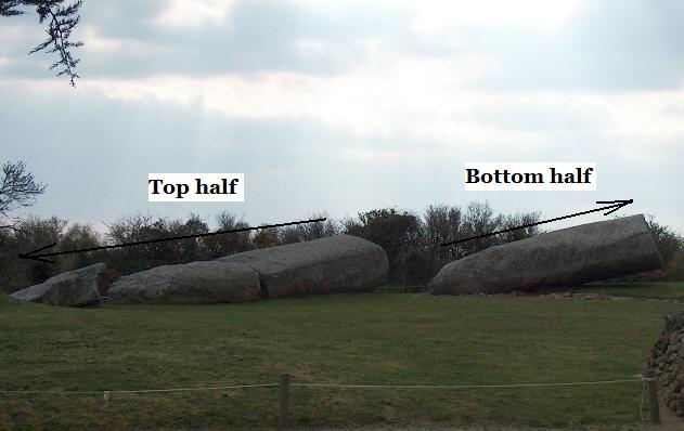
which is a broken up menhir (or obelisk, as some might call them) at Carnac, in France, where there are a huge profusion of them, giving rise to theories such as
How the 55m long alignment would have looked in its original form.
Taken from here:
http://www.ancient-wisdom.co.uk/francelegrandmenhir.htm
|
|
| |
|
|
|
Mick Harper
Site Admin
In: London
|
|
|
|
The first picture shows you what a menhir is, it is a filthy great column that you stick on a cliff top to tell mariners that it is safe to land and join the Megalithic System.
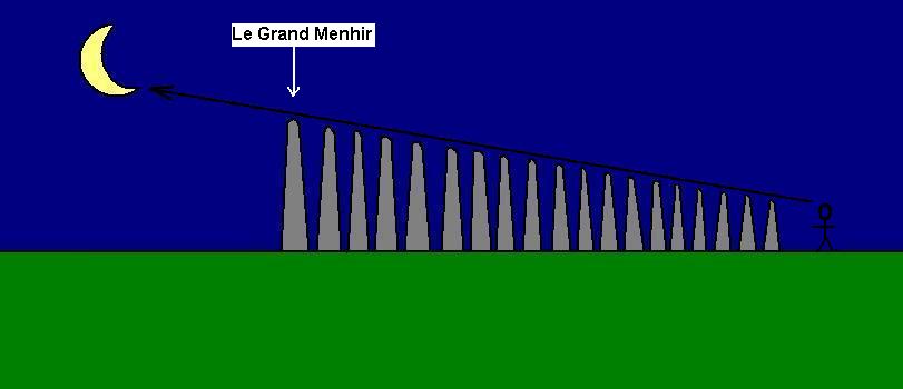
However before we go on, since you haven't been doing any work lately, I'd like you all to have a guess at what the second pic suggests. And obviously take no notice of the proffered explanation -- I cannot think of a more ludicrously expensive way of taking a simple sighting. Honestly these people... However there must be a reason why all these menhirs are found together at Carnac. What is it?
|
|
| |
|
|
|
Hatty
Site Admin
In: Berkshire
|
|
|
|
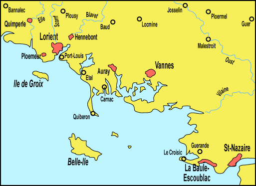
Carnac is situated in a sheltered bay protected by the Quiberon peninsula which resembles a giant jetty (see oversized map) yet accessible to the Atlantic.
| I cannot think of a more ludicrously expensive way of taking a simple sighting. Honestly these people... However there must be a reason why all these menhirs are found together at Carnac. What is it? |
The number of menhirs and assorted stones is on a "stupendous scale" (though apparently several thousand stones have since been commandeered for building projects) for all the world like a production line awaiting collection. But why go to Carnac rather than Dartmoor, say? It's a more navigable coast-line peut-etre?
|
|
| |
|
|
|
Mick Harper
Site Admin
In: London
|
|
|
|
The Megalithic System, generally speaking, is designed to make use of local features, local materials and (presumably) local labour. However this is not always technically possible and clearly the construction of gynormous obelisks is not only a skilled job in its own right, it can only be done where suitable stone is available.
Hatty asks, why not Dartmoor? Well, it must be remembered that the Megalithic System was a Europe-wide phenomenon. The British aspect (even allowing for the fact that it appears to be British-originated) is something of an artefact arising from the British mania for a) walking and b) antiquarianism. Carnac is actually situated right in the middle of Megalithia and, as Hatty also points out, is absolutely perfect for popping obelisks onto sea-going barges. Which Dartmoor is not.
Anyway, Carnac was chosen for the serial production of menhirs. To judge from the evidence still lying around, it looks as though Carnac was also in the business of supplying ready-cut stones for stone circles as well, which makes sense because there are plenty of places without suitable local geology.
PS Anyone wondering why I am so enthused with this topic right now might guess that I am currently writing a book (with Hatty) but from now on I shall be just posting up in the ordinary way as things occur to me rather than operating an ersatz Treasure Hunt. Many thanks for those of you have assisted me in getting my thoughts straight. As usual, all this has been more for my benefit than yours.
PPS As far as I know this Mercantile Origin Of The Stones is original to me but if anyone comes across similar explanations would they sing out.
|
|
| |
|
|
|
Chad

In: Ramsbottom
|
|
|
|
| However there must be a reason why all these menhirs are found together at Carnac. What is it? |
It's a shop window display...GET YOUR MENHIRS HERE - - WE STOCK ALL DIFFERENT SIZES.
|
|
| |
|
|
|
Mick Harper
Site Admin
In: London
|
|
|
|
Why would you want different sizes, Chad? I mean specifically. If you are just sticking them on clifftops to advertise that hereabouts is a good place for a megalithic ship to dock (which is the use I will shortly be outlining), then any reasonable size will do.
I am not asking this as a quiz-question, it's just I can't think of a specific reason why you'd have any particular size apart from 'noticeable'. However it's a reasonable area for speculative suggestions since it chimes well with simple astronomical navigation.
|
|
| |
|
|
|
Hatty
Site Admin
In: Berkshire
|
|
|
|
There are rows of standing stones in Dartmoor at Merrivale surrounded by burial mounds and quarries, nothing like the scale of those at Carnac. What's interesting, in view of the 1st May sunrise finding, is that apparently the Merrivale stones, in double rows with a west-east orientation, point towards the Pleiades or 'Seven Sisters' at the May sunrise (not sure of the exact day in May).
There seems to be a dual purpose with both line-of-sight and a 'warehouse' aspects but it's hard to tell whether the stones, which are relatively insignificant in size, are still in their correct positions; since one of the rows contains a stone circle it would suggest that Merrivale was intended as a major landmark. (Incidentally, there are more bogs on Dartmoor than on Bodmin Moor.)
|
|
| |
|
|
|
Mick Harper
Site Admin
In: London
|
|
|
|
Mention of warehouses brings us to dolmens, which are generally described, in the ineffable way of the archaeo-savants, as places of ritual worship or burial places. However they are in fact the megalithic equivalent of bonded warehouses (their most notable characteristic is that they are always perfectly weatherproof -- either because the roof and supports are single slabs of rock or they are dry-stoned walled with great precision).
But before we see how they fit into the picture let us emphasise the fundamental nature of the Megalithic System. Since it is designed to be relatively maintenance-free and to last indefinitely (it actually did last for at least four thousand years) it is no use relying on political power which is always highly evanescent. No, it relies wholly on the voluntary principle. You can either take part or not as you prefer.
Let us apply the principle of 'what is is what was' to coastal communities. What are they always like? Well, they come in two models: either they like to be left alone to do their thing (fishing, crofting, what have you) or they want to get involved (there's money in trade and people). So when Carnac Inc come along and ask whether you want to sign up, you can either decline in which case nobody will bother you or you can say yes please and have three things installed:
1. a menhir on your local landmark
2. a stone circle
3. a dolmen.
And quite soon people will start bothering you.
|
|
| |
|
|
|
|


