| View previous topic :: View next topic |
Pete Jones
Site Admin

In: Virginia
|
|
 |
|
Questions I have:
Why should there be geographical symmetry?
How much symmetry is there?
What counts as actual symmetry versus merely apparent symmetry?
If there is real symmetry, what do the symmetrical spots on the planet have in common? etc etc. I have thought (for the last ten years) that Expanding Earth (and not Plate Tectonics) is the correct paradigm. (But am only now reading SLOP, so...)
On the EE model, the dark rift running through the spine of the Red Sea is an expansion zone, highly volcanic, and at the south end, a volcano sprouted in the rift. Over time, the rifting continued and the volcano was parted down the middle. And now what is left are two clusters of islands symmetrically placed on either side of the rift (just to the right of the "Eritrea" label).

There are many more instances of symmetry all over. What I wonder about are the symmetrical forms under the oceans.
I also wonder about how much sediment is present at any given spot. I don't know if thicker sediment would obscure the visible detail underwater or not (or to what extent)
|
|
 |
|
 |
|
Pete Jones
Site Admin
In: Virginia
|
|
|
|
This one is underwater, in the South China Sea. The spine down the middle is less obvious, and is not a rift so much as a series of peaks. I trace it from directly above "West Philippine Sea" going southwest at an approximately 45-degree angle.

First: The Spratly Islands are directly opposite of a similar structure due south of the Paracel Islands. This structure south of the Paracels (the reflection of the Spratlys) does not break the surface like the Spratlys do, but still appears to be its reflection. Both are approximately perpendicular to the rift/peaks (just like the islands in the Red Sea above).
Second: Both the Spratlys and the Paracels are two-part structures. A light blob to the northeast (of each) and a more mountainous looking region to the southwest. Both parts are opposite each other.
Third: Extended further on the left side of the picture and the two island groups appear to be at the ends of a large area of general unevenness.
Fourth: And the southwest-most area of the spine/rifts/peaks comes to a point, similar to the Red Sea Because of the variations of smoothness and unevenness, I like to think that the smooth areas represent a relatively fast splitting. Why? Because other rift valleys which dominate the sea floor---or, at least, everywhere except in the Pacific, where they appear very different---are not smooth at all. They are very rough.
|
|
| |
|
|
|
Pete Jones
Site Admin
In: Virginia
|
|
|
|
Pacific Ocean
I will post more "small" ones, but here is the largest one I can find. I am on the fence about whether it counts. Some facts about it---in addition to its basically symmetrical appearance---are suggestive.

And here are lines drawn on Google Earth over the top of the parts I see as symmetrical:

The yellow lines have curious measurements:
The top two "mirrored" lines are each between 2300 and 2400 km.
The bottom endpoints for the lines are not arbitrary: they end on a prominent rift line. This line is where the bottom two mirrored lines start.
And those two southern lines are between 3400 and 3620 km in length. The western line ends at the south end of Hawaii (big island), a fairly objective endpoint
The bottom of the eastern line ends at the first major rifting that I can see, at 3400 km.
However, if you simply excise the rift zone that this line runs into at the 3400km-mark, and then continue the line down to the next structure (the massive underwater structure north of New Zealand), then you get a 3680 km measurement.
3620 km for the Hawaii line, and 3680 km for its mirror.
|
|
| |
|
|
|
Pete Jones
Site Admin
In: Virginia
|
|
|
|
Excising the Rift
The logic here is that the rift and subsequent spreading of the seafloor (i.e., expansion of the globe) happened after the larger superstructure came into existence.
The yellow line is a 370 km rift zone, which I cut out. I then continued my overall measurement below it, to measure what would have been the situation before the rift.

Tangentially, I don't know what or if there is an orthodox explanation for the apparent symmetry of this huge structure in the Pacific. I'm not looking it up because I wouldn't know how to look, or where. Which is nice.
And while I think Expanding Earth theory might have something to say about it, I wonder about the timeframes that they'd assign to its creation (presumably from an oceanless earth that grew its ocean basins over time).
Whereas you can see the fit of the South America against Africa, with the seafloor ridge running down the Atlantic, there are no north-to-south ridges in the Pacific, and the ridges that do exist seem to creep into what look like east-to-west seams. In the pic here, the yellow line covers a rift structure that is mainly east to west.
|
|
| |
|
|
|
Mick Harper
Site Admin

In: London
|
|
|
|
The reason Continental Drift was converted, more or less overnight, from 'strictly-for-crazies' to being an observably true basic paradigm (and renamed Plate Tectonics) was the discovery of sea-floor spreading in the mid-Atlantic ridge. A vent in the ocean bottom allowed 'magma' to emerge and settle (in stripes) on either side.
You'll have to ask them how this managed to push plates the size of continents apart but it did produce geographical symmetries.
|
|
| |
|
|
|
Pete Jones
Site Admin
In: Virginia
|
|
|
|
This northernmost section of the Southern Ocean, about where it "joins" the Indian Ocean, is one fascinating piece of symmetry. The area I'm going to look at in the following posts is 37 million square kilometers (per Google Earth). Here it is:
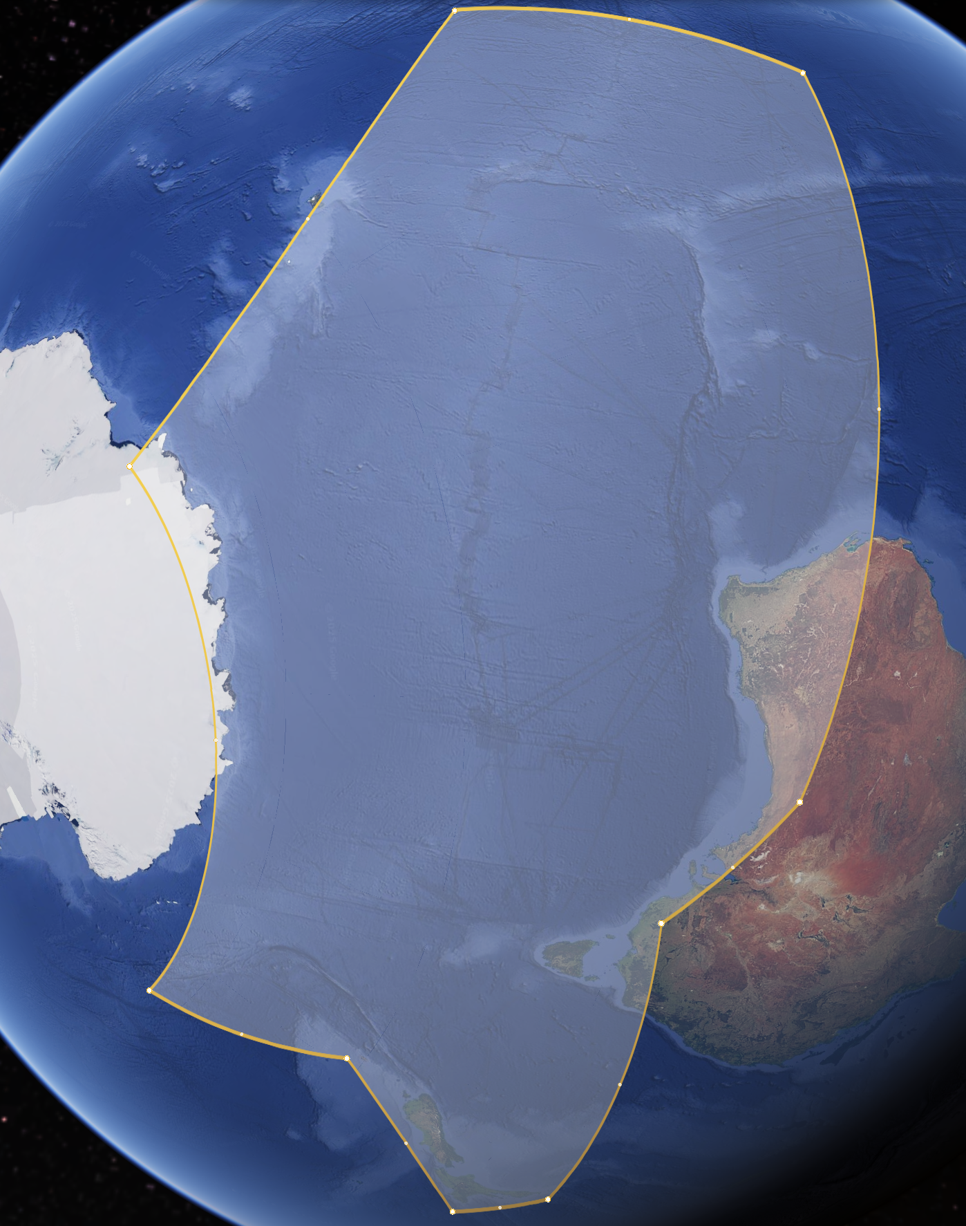
I've arranged it in this alignment, because it's easier to visualize what will come later. In this yellow-line enclosed shape, we'll be moving top to bottom (which will be east to west in reality).
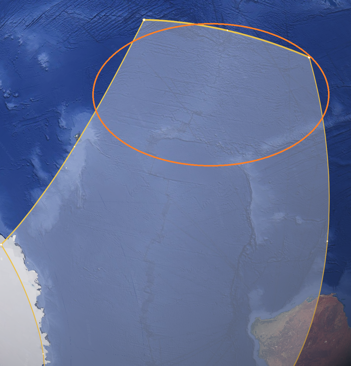
The first area of focus is here:
|
|
| |
|
|
|
Pete Jones
Site Admin
In: Virginia
|
|
|
|
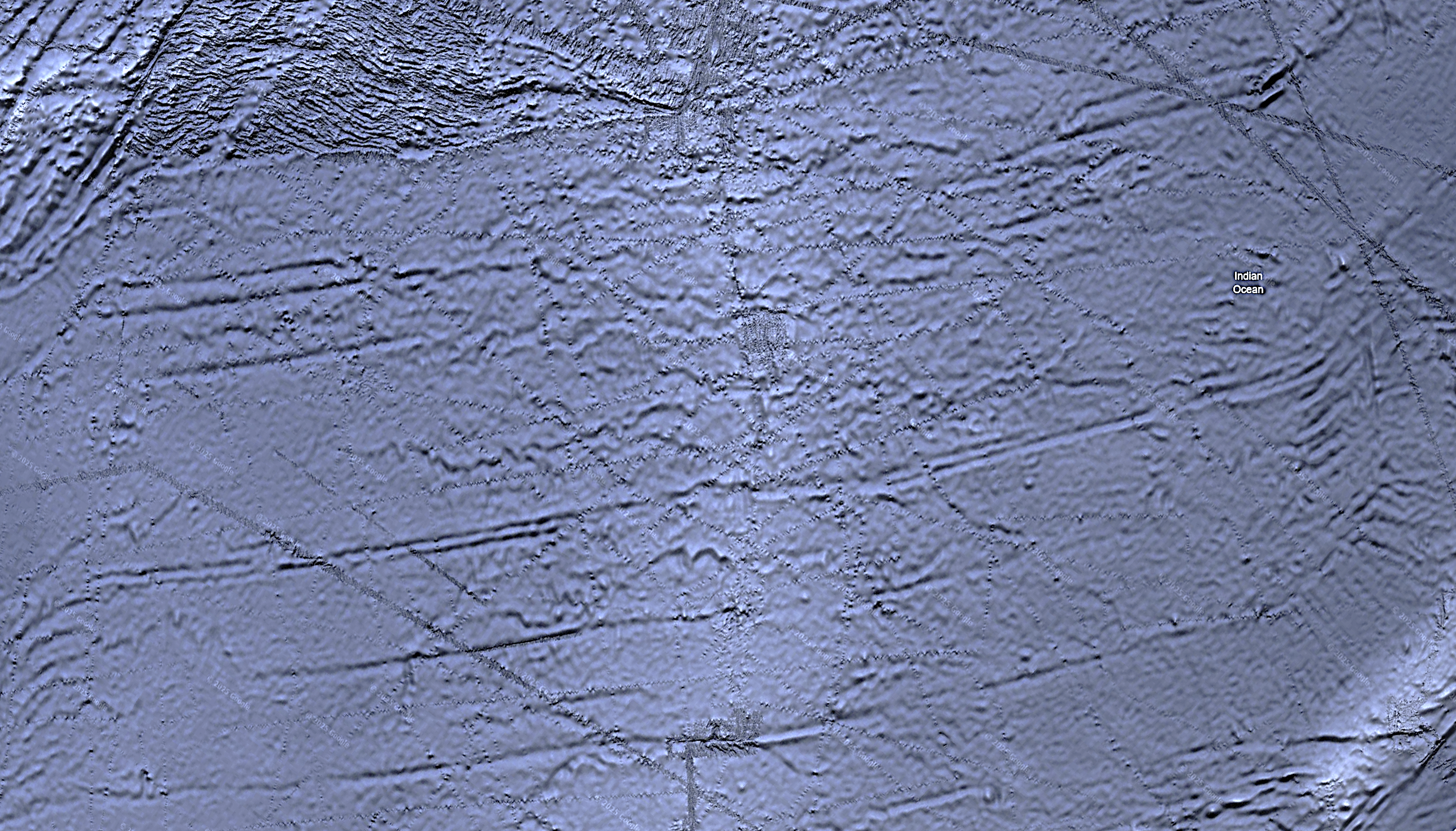
This is what the focus area in the orange circle above looks like "up close" (with some color and contrast changes to make the shape more visible)
And if you don't already spot some symmetry, here's what pops out at me:
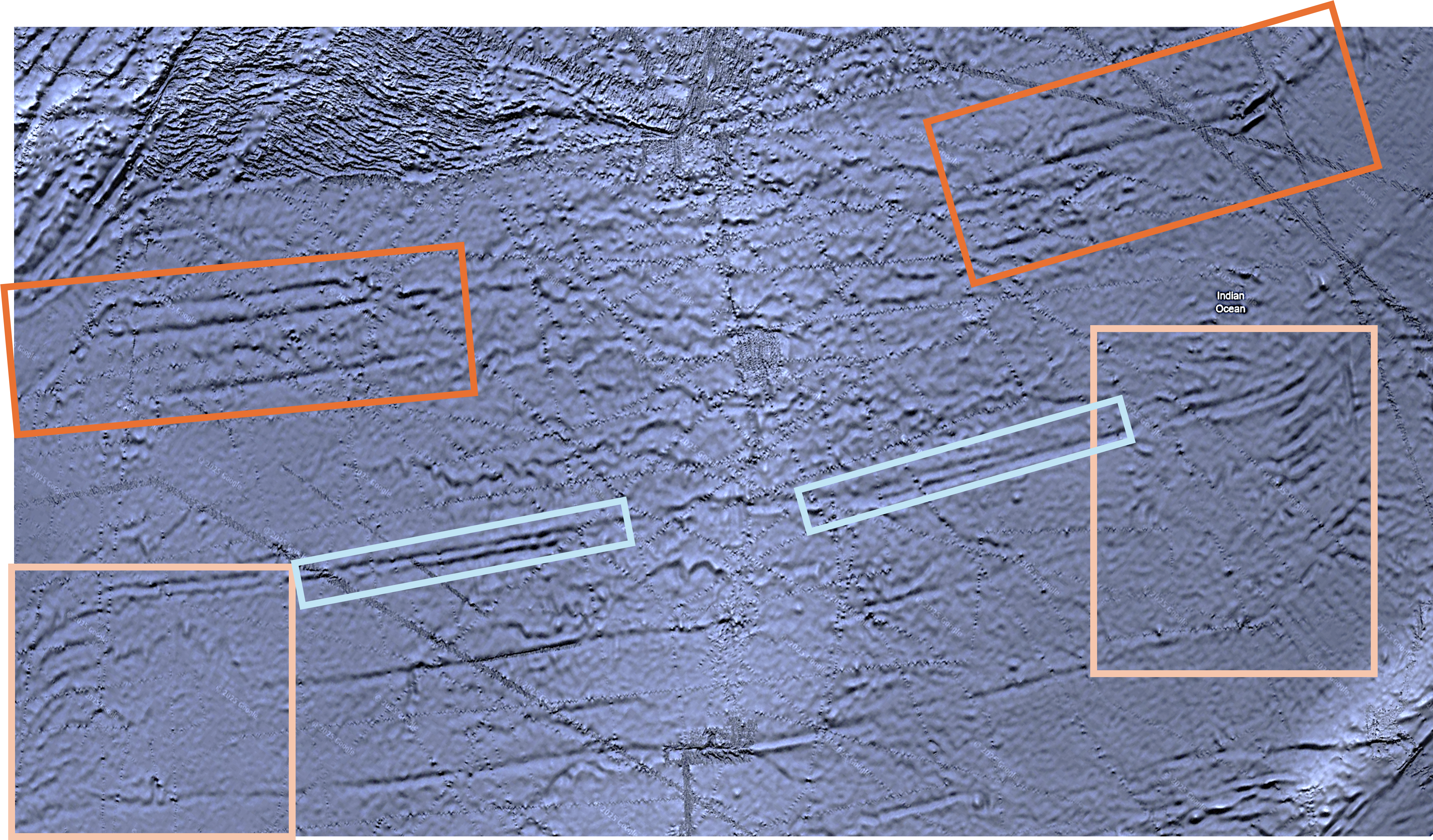
These segments are symmetrical the closer they are to the center line of the structure, but they reverse directions on the edges. Note the "squinty eyes" in the orange boxes. The outside edges of each "eye" slant in a sort of mirror image of the other.
Same goes for the lower pink boxes, the outer portions slope in opposite directions.
This is about 4 million square kilometers of symmetrical seafloor topography.
|
|
| |
|
|
|
Mick Harper
Site Admin
In: London
|
|
|
|
If I saw the 'rushes' I would assume the lab had made a mistake and duplicated the image. I am surprised this hasn't been picked up by Graham Hancock et al. I'm surprised I'm not seeing it regularly on the National Geographic channel.
I would have thought the parallelism and the regular spacing is even more significant than the symmetry.
|
|
| |
|
|
|
Pete Jones
Site Admin
In: Virginia
|
|
|
|
(I suppose I've been lumping parallelism and spacing in with the idea of symmetry. But we'll come to both explicitly.)
As we move down our 37 million mile swathe of Southern Ocean, we get to this structure, next: "The Warthogs."
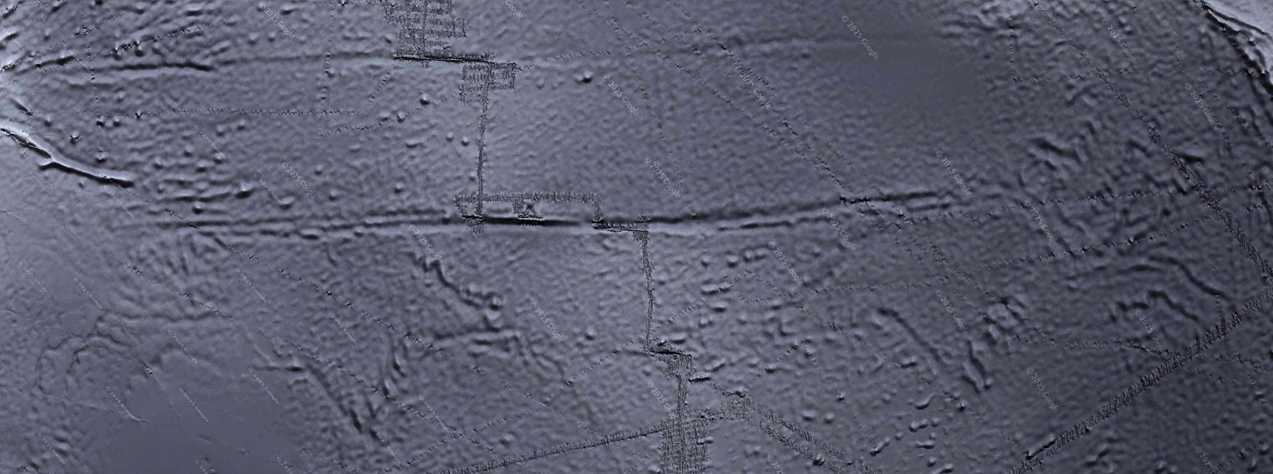
The symmetry pops out. But just in case you’re pop-blind, here’s what I see:
The red boxes are less clear, but they both have the same basic shape, call it a branching shape. The orange circled areas speak for themselves, I think. Two warthogs facing off, across a center line.
Stay tuned for the regular spacing, which is, as you say, more significant
|
|
| |
|
|
|
Pete Jones
Site Admin
In: Virginia
|
|
|
|
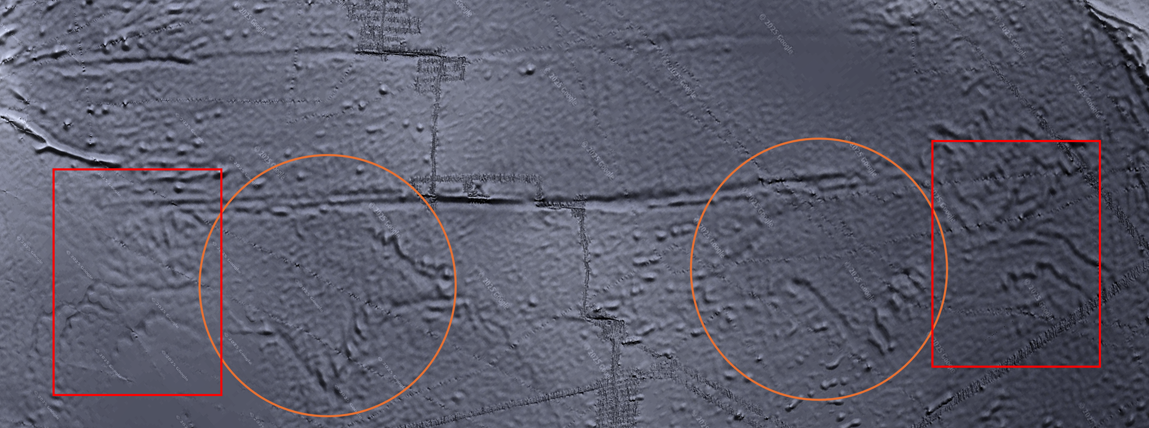
We keep going. The next thing is a relatively huge(r) structure adjacent to those above. I added measurements and some starting and stopping points (which I had to choose). Note The Warthogs, right in the center:
A 2600+ km wide structure, neatly divided in half. For perspective, 2600 km is the distance from the Atlantic coast of Delaware USA to the base of the Rockies in Denver. Or the distance from London to Crimea.
The structure is also (more roughly) 1200 km "tall"
|
|
| |
|
|
|
Pete Jones
Site Admin
In: Virginia
|
|
|
|
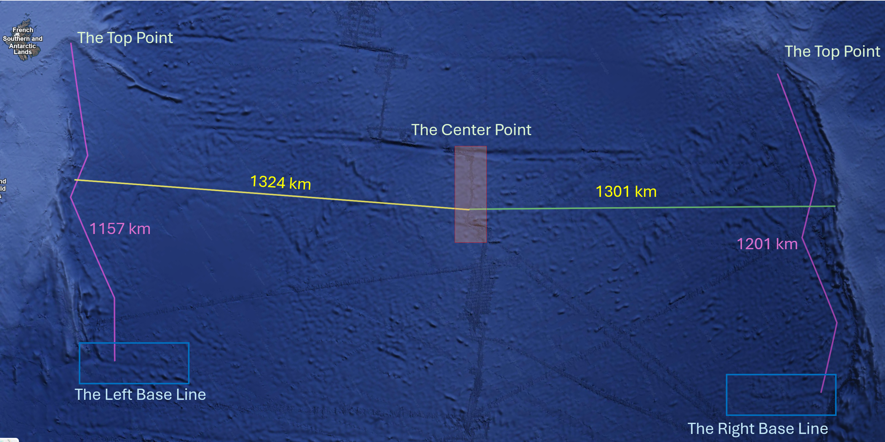
The Various Points Along the Way
Center Point. It is not arbitrarily chosen, because there is a clear ridge line (assuming the line is not an artifact of Google Earth imagery). The Center Point ridge line is basically equidistant from the warthogs’ snouts.
The Left and Right Base Lines. These are convenient because they are visible as lines. I’m calling these choices non-arbitrary, also.
Purple Lines. As you go up the purple lines, the shapes are similar but not exact. Given all the other exact symmetries, I’m counting this as good enough. The top points are less certain.
The left side Top Point ends at a definite structure. And there is a line heading to the right that connects basically with my top point on the left
The right side Top Point is also a structural terminus of a sort, but the line heading out to the left is non-existent. But then it appears, faintly, about 600 km out in the ocean heading to the center line.
|
|
| |
|
|
|
Mick Harper
Site Admin
In: London
|
|
|
|
|
The last pic needs to be narrowed, it's skew-whiffing the whole thread. Talking of which, I've done my bit today.
|
|
| |
|
|
|
Pete Jones
Site Admin
In: Virginia
|
|
|
|
|
600 it is, forevermore
|
|
| |
|
|
|
Mick Harper
Site Admin
In: London
|
|
|
|
Assuming you have not left anything out, there does not seem to be any objections cherry-picking-wise. The symmetry aligns with the axis of the earth sufficiently to add that to the mix, though not with the exactness that demands the present axis is put in the frame. (Unless I am misreading up and down, something I have as much difficulty with as left and right.)
But all together, there's definitely a case to answer. For me personally, answers come there not.
|
|
| |
|
|
|
Pete Jones
Site Admin
In: Virginia
|
|
|
|
Turns out, left to right/west to east is more convenient now, and so I'm flipping it (notice the Warthogs faintly on the left side). The next adjacent area is the span between Antarctica and the Australia:
I expect to find a 2600-ish km gap. And the yellow line below is 2600 km exactly.
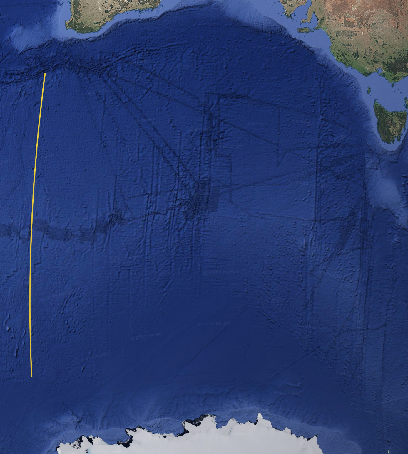
The top starting point is clear: it's a continuation of the structure we've been looking at (which was on the right side, in the previous posts).
The end point is less clear, but I think defensible. I won't defend it right now.
|
|
| |
|
|
|
|
