| View previous topic :: View next topic |
Chad

In: Ramsbottom
|
|
 |
|
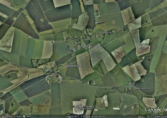
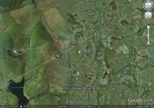
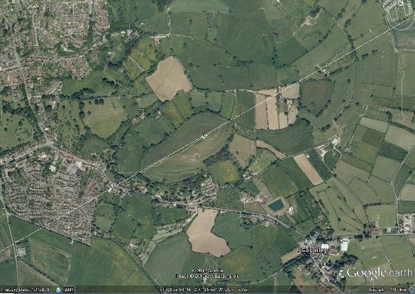
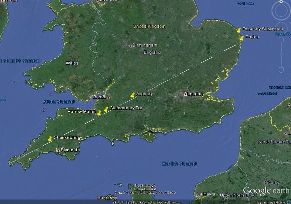
You've done a brilliant job on this Hatty. I plotted your version of the Michael line and got some great hits... without even the slightest tweak.-
This is as it passes through Avebury. (I almost hit your crossroads):-
And it passes within about two hundred metres of the Cheesewring:-
But best of all... look at Glastonbury Tor!
And as I said, this is without even the slightest iota of a tweak.
|
|
 |
|
 |
|
Mick Harper
Site Admin

In: London
|
|
|
|
[Sorry, this has been overtaken by events and refers to Hatty's map]This kind of map is not what is needed. Have a look at this
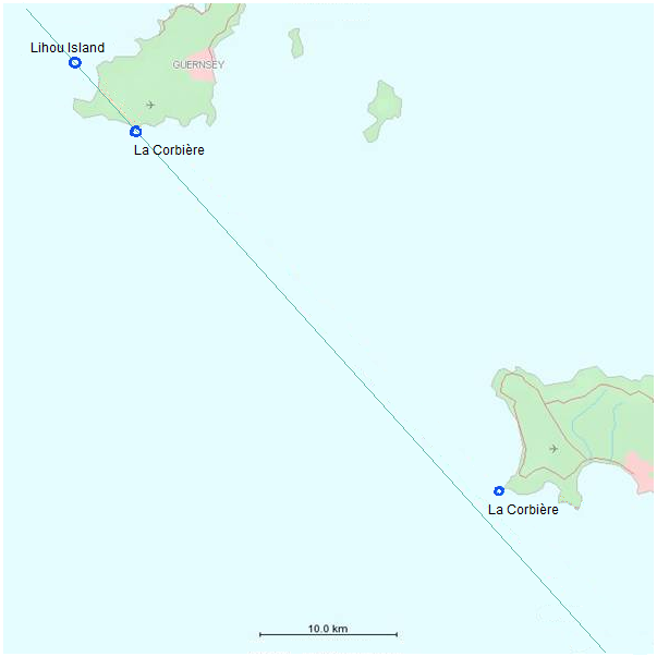
and we can see immediately whether "the line" runs through or runs past wherever we want. Then we superimpose this on a larger scale map, eg
Now it is true that this line was slightly juggled and it is also true that even at the least scale the line might miss the two Guernsey Venus Pools by (say) anything up to a mile but the point is, "it's good enough".
Of course we would like somebody to actually discover whether it runs through or misses by a mile but that is only the next question. And if necessary it can be suppressed (reasonably legitimately) in a polemical work.
|
|
| |
|
|
|
Mick Harper
Site Admin
In: London
|
|
|
|
|
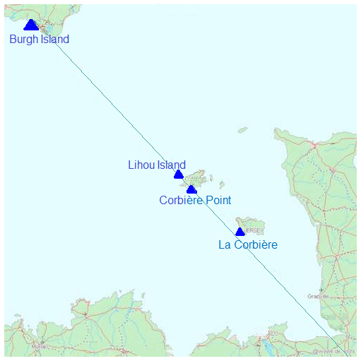
Truly stunning, Chad. Hatty: please convert these into DVD friendly images!
|
|
| |
|
|
|
Mick Harper
Site Admin
In: London
|
|
|
|
|
Glastonbury Tor must be a freak result!
|
|
| |
|
|
|
Chad
In: Ramsbottom
|
|
|
|
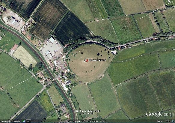
| Mick Harper wrote: | | Glastonbury Tor must be a freak result! |
Then so must be Burrow Mump!
|
|
| |
|
|
|
Mick Harper
Site Admin
In: London
|
|
|
|
By the way, it is conventional to put leylines over mumps and bumps but to act as tangents when passing stone circles. Burrow Mump qualifies both ways! How does Avebury (the various circles both extant, reconstructed and hypothesised) fare using this?
Also, if this truly is the Michael Line then we need to know more about Corton. How far is it from Ormesby St Michael and Ormesby St Margaret? I shall be upset to lose those.
|
|
| |
|
|
|
Chad
In: Ramsbottom
|
|
|
|
| Mick Harper wrote: | | How far is it from Ormesby St Michael and Ormesby St Margaret? |
'Fraid it takes them out of the picture.
|
|
| |
|
|
|
Tilo Rebar

In: Sussex
|
|
|
|
| Hatty wrote: | | This is the Michael Line, Land's End to Corton version... |
There happens to be another village called Corton, this time in Wiltshire. It's just SE of Warminster, close to the villages of Heytesbury, Knook and the lost village of Imber containing the beautiful 13th century St Giles church.
Plenty of evidence for large scale megalithic occupancy around this area. Wonder how close it is to the Dragon line?
|
|
| |
|
|
|
Hatty
Site Admin

In: Berkshire
|
|
|
|
Corton, Wiltshire isn't on the Michael Line. But it is on a great circle, just above the 51st line of latitude, that links Goseck in Germany to Stonehenge.
If you extend the line beyond Stonehenge it reaches Glastonbury; not the Tor but Street, which is of course straight. It's also the intersection of another meridian but that's enough excitement for now.
I'm glad Corton has been brought to everyone's attention, thanks to Tilo. I hadn't even noticed it before!
|
|
| |
|
|
|
Boreades

In: finity and beyond
|
|
|
|
Bing Bong: Service Announcement
Will the drawer of the Michael Line please collect the following places and add them to the collection.
Restormel
The Hurlers stone circles
Cosdon Stone Row
Cadbury Castle
Dorchester Henges
Ivinghoe Beacon
I can't believe Hattie missed that last one ;-)
|
|
| |
|
|
|
Boreades
In: finity and beyond
|
|
|
|
|
Fiddly things these alignments. I can't make up my mind whether it's Silbury Hill or Avebury that I should be using as a mid-point. It does make me wonder what exactly we are trying to align. Is it just hilltops, or hilltops and henges?
|
|
| |
|
|
|
Mick Harper
Site Admin
In: London
|
|
|
|
Not sure what alignment you are talking about but I don't think, on any version, that Silbury Hill is claimed to be on the Michael Line. It "overlooks it" as we say in our forthcoming DVD.
Also, you cite above the Hurlers Stones. But these are a stone's throw (as giants go) from the Cheesewring so, unless one is lined up behind the other, presumably both cannot be on the line.
The alignment we are using starts at Lands End (not St Michael's Mount) runs over both Barrowbridge Mump and Glastonbury Tor and runs through Avebury stone circle. That doesn't give a lot of scope for wriggle room.
|
|
| |
|
|
|
Chad
In: Ramsbottom
|
|
|
|
| Boreades wrote: | Restormel
The Hurlers stone circles
Cosdon Stone Row
Cadbury Castle
Dorchester Henges
Ivinghoe Beacon |
The closest one is Ivinghoe Beacon... and even that isn't close enough to get excited... it's just another "overlooker" (if you've got good eyesight).
|
|
| |
|
|
|
Boreades
In: finity and beyond
|
|
|
|
I have to admit that, once you start staring at maps and dots on Google Earth (etc), it's all too easy to see patterns you want to see.
Just so we're playing the same game, to find places that are statistically significant, how wide is The Michael Line allowed to be?
Have we mentioned the Michael Line that goes to Ireland?

|
|
| |
|
|
|
Hatty
Site Admin
In: Berkshire
|
|
|
|
The Michael Line can be as wide as you like since technically it isn't a line but a series of landmarks/signposts.
The Irish Michael Line came up in one of the threads as the 'Michael-Apollo Line'. The route's supposed to extend down to the eastern Med and the Middle East via Michael places. Using Google Earth to connect Skellig Michael and Temple Mount, Jerusalem soon dispels the notion though it crosses Etretat which is interesting.
|
|
| |
|
|
|
|