| View previous topic :: View next topic |
Chad

In: Ramsbottom
|
|
 |
|
| Mick Harper wrote: | | See...I told you. I demand unanimous support on this vital question. |
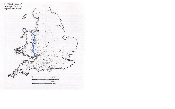
There should be relatively few hillforts in Wales to the right of the blue line (to correlate with your rainfall map).
Should have gone to Specsavers.
But joking aside, it’s not necessarily total annual rainfall that determines the amount of erosion… it’s how hard it comes down when it does actually rain.
So yes... you have my support.
A relative of mine owns a farm someway to the right of that blue line, in mid-Wales. He lets a local sheep farmer use most of the land, but the part he has retained and landscaped is troubled by erosion and he has had to learn to employ various methods to control it.
And when it rains… it makes Manchester seem arid.
|
|
 |
|
 |
|
Ishmael

In: Toronto
|
|
|
|
| Mick Harper wrote: | | See...I told you. I demand unanimous support on this vital question. |
In the north, we clearly have as much rainfall as in the south-west but no hill-forts so rain does not cause hill-forts.
Furthermore, there are those two anomalous low rainfall spots in the west and they do seem to overlap a cluster of hill-forts. We should see fewer such hill-forts there than in the surrounding area. We don't seem to.
|
|
| |
|
|
|
|
|
|
|
|
| Mick Harper wrote: | | Just to clinch the matter, the very dark blue areas have few hillforts because these are the very high ground (Cambrian Mountains, Dartmoor, Exmoor) which are not suited to farm animals that have to be 'kraaled' every night. |
Whether some Hill forts started as animal enclosures is not very important as most ended up with elaborate ditches and ramparts, round houses, storage pits and many have been found with sling stones, fire damage and weapons.Seem like forts.
Since they are surrounded by villages named 'dun' in Ireland, Isle of Man, Scotland, England and Isle of Wight with clusters near the 'downs', seemingly these villagers thought they were near a fort and not an animal compound, I suggest.
|
|
| |
|
|
|
DPCrisp

In: Bedfordshire
|
|
|
|
| Hatty wrote: | | Is there a connection between dun/don and dung? |
Surely yes: it drops down and forms, or is formed into, a heap (dune). (It really only applies to the droppings of livestock who defecate while standing upright, dunnit? Not e.g. cats and dogs.)
"Ultimate origin unknown"
|
|
| |
|
|
|
DPCrisp
In: Bedfordshire
|
|
|
|
| Mick wrote: | | I demand unanimous support on this vital question. |
I can't see a correlation either.
| Pulpy wrote: | | it appears... the builders of these 'forts' came from the west |
Yes, that's pretty much where this thread came in.
Frank gave us data from Hogg, including the fact that hillforts don't occur above so-many meters altitude, and that they tend to be larger and fewer in the east. I gave an interpretation... that so far hasn't been challenged.
Undergrowth inhibits erosion, innit.
|
|
| |
|
|
|
DPCrisp
In: Bedfordshire
|
|
|
|
| Given the number and distribution of the dots, surrounding each with an eight-mile circle surely covers so much of the country as to render any correlation meaningless. Step forward our house mathematician to arbitrate! |
Ahem, a mere 4 pages back, someone said:
| There are just over 100 dons, duns, downs and dens in England on the 4 inch road map... They are always within about 4 miles of a Hill fort except a couple in Norfolk (which may indicate a lost Hill fort thereabouts) and never elsewhere. Some pockets of Hill fort territory have none. |
So, there are places with hillforts but not don/dun/down/dens and places with don/dun/down/dens but not hillforts. 100 places scattered across England would be 22 miles apart, on average; but there were something like 1000 hillforts, averaging 7 miles apart. Without much more detailed work, "within about 4 miles of a hillfort" is "anything up to half way between neighbouring hillforts", which is no correlation at all. | |
|
| |
|
|
|
DPCrisp
In: Bedfordshire
|
|
|
|
There's not very much to choose between them, is there?
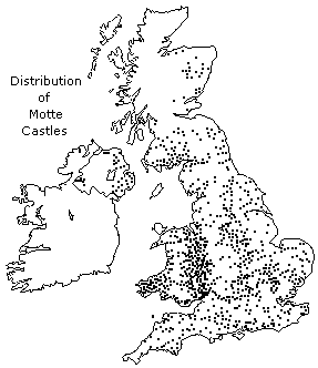 
Especially in Pembrokeshire... which isn't a border between cultures.
The Normans didn't like to live too high, too far from the madding crowd, either, innit.
Looks like they invented the M4 corridor, too. (I expect a lot of London castles/"castles" have been rubbed out.)
|
|
| |
|
|
|
Hatty
Site Admin

In: Berkshire
|
|
|
|
| Surely yes: it drops down and forms, or is formed into, a heap (dune). |
If it keeps forming a heap, would the enclosure get higher and higher over time? If hillforts were animal enclosures there'd be a lot of dung to put somewhere. You see mountains of horse manure from nearby stables in these here horsey parts; what happens to it all? It gets spread around and just disappears into the soil, you'd think, but apparently it doesn't.
Especially in Pembrokeshire... which isn't a border between cultures.
The Normans didn't like to live too high, too far from the madding crowd, either, innit. |
There's an old castle site beside Rhosilli beach on the Gower peninsula, it isn't up on Rhosilli Down. Not much left, just dunes and ditches, but it's not been washed away. The erosion of the cliffs on the other side of Worm's Head is severe enough for Rhosilli church to fall into the sea c. 1200 (the replacement church, further inland, has a standing stone next to it) but Worm's Head itself carries on regardless, even though battered by Atlantic gales and the Bristol Channel's famously high tides. So I asked a geologist how come the causeway hasn't been eroded too and he said it's "a different kind of limestone". Eh? His explanation is it doesn't have cracks in the rock like the limestone cliffs but that's clearly wrong, there are lots of rock pools and fissures visible.

Maybe there's something plugging the crevices in the causeway bed, that doesn't get washed away because it's soft and squidgy enough to be pushed down. The sheep on Worm's Head are popularly said to provide the tastiest lamb ; they are also said to be particularly attached to it (apparently to do with the salt in the grass) and try frantically to return if taken inland, some even drowning in the attempt. Whether true or not, it shows that there's a tradition of keeping sheep on Worm's Head.
| Looks like they invented the M4 corridor, too. |
There's a series of castles and forts beside the Thames. Some are in hotel grounds. Some were destroyed in the seventeenth century in the Civil War but presumably they'd survived pretty well till then.
|
|
| |
|
|
|
Pulp History

In: Wales
|
|
|
|
Pembrokeshire became a border between the English speaking south and the Welsh speaking North (of Pembrokeshire) .... the Landsker line dividing the two areas. The south was an Anglo - Norman colony and the North was indigenous types.
_________________
Question everything!
|
|
| |
|
|
|
|
|
|
|
|
| DPCrisp wrote: | Ahem, a mere 4 pages back, someone said:
There are just over 100 dons, duns, downs and dens in England on the 4 inch road map... |
This has been updated on my Knol, I've found several hundreds of dun/don/down farms and villages to date. The visible correlation between Hill forts and don/down/dun/dinas looks persuasive, particularly as 'dun' apparently means a fort, presumably included in the settlement names to indicate proximity to the HF .. castles were much later and didn't generate many villages adopting the term, so presumably few new settlements were created.
Also there are many dun(Gaels?) and don/downs(English?) in Scotland which perhaps infers the former villages were also generated when the Hill forts were lived in or shortly thereafter.
In contrast to HFs the castles (mostly built by the Normans) have a fairly uniform spread on your diagram but with few in western Scotland, where HFs and 'dun' villages are plentiful.
In contrast the earlier Romans appear to have attracted much 'English' economic interest with nearby Wick, Chester and Bury farms and settlements generated.
|
|
| |
|
|
|
Mick Harper
Site Admin

In: London
|
|
|
|
|
I'm not listening. I've got a book to write.
|
|
| |
|
|
|
Mick Harper
Site Admin
In: London
|
|
|
|
|
By the way, the reason why Drovers routes are so often along ridges eg The Ridgeway is not because drovers like being up there in the cold and wet and wind but because the animals constantly progressing along drovers routes make natural wattle-and-daub, just like in enclosures, so they too erode less and soon stand proud over the landscape.
|
|
| |
|
|
|
Hatty
Site Admin
In: Berkshire
|
|
|
|
|
James Dyer again (in Ancient Britain) writes about causewayed enclosures as most probably defensive forts and in the next para says "after these defended enclosures went out of use, no further defensive sites are known until the appearance of hillforts a thousand years later." Er, too busy cutting down trees and stuff to bother with battles?
|
|
| |
|
|
|
DPCrisp
In: Bedfordshire
|
|
|
|
| James Dyer again (in Ancient Britain) writes about causewayed enclosures as most probably defensive forts |
How can he say that with a straight face?

|
|
| |
|
|
|
|
|
|
|
|
| Hatty wrote: | | Er, too busy cutting down trees and stuff to bother with battles? |
Presumably much of any further tree felling took place in the lowlands which prior to 1st millenium BC were not heavily settled according to Hill fort distribution. I imagine the introduction of iron working was relevant to opening up this territory.
|
|
| |
|
|
|
|
