| View previous topic :: View next topic |
Hatty
Site Admin

In: Berkshire
|
|
 |
|
| Grant wrote: | | You've explained something which has always bugged me about Stonehenge: why is it so shit? Why did they drag these stones so many miles with so many people but hardly bother to dress them. Where are the carvings on them? And why, despite the desperate efforts to make them burial grounds, are so few interesting things ever dug up around them. All these questions are answered if they were "just" navigational aids. |
I agree, it's so "obvious" isn't it. When you look at the landscape with Mick's insights you see it as an engineering challenge not a mystic maze. There are naturally shrines and important sites like burial places en route as well as commercial outlets just as people today want to get to business meetings, a place of worship or the theatre as quickly as possible without taking a wrong turning.
|
|
 |
|
 |
|
Mick Harper
Site Admin

In: London
|
|
|
|
| The two main routes, the Ridgeway and the Icknield Way, cross the Thames at Goring near Streatley. The Goring Gap is described as "an interesting geological feature" cutting through the hills at a point where the Thames runs in a north to south direction. |
The Megalithic System, as well as being low-maintenance, also seems able to marshall huge resources when it comes to terraforming. We have seen elsewhere that something like Glastonbury Tor is almost certainly man-made and we should be very suspicious when phrases like "interesting geological feature" coincides with an absolutely unique point, where the main Megalithic route crosses the only major river.
Orthodoxy holds that practically everything is natural. Silchester is accepted as artificial ("the largest earthwork in Europe") but that's as far as they will go. We tend more to the proposition: "Never mind the geology, inspect the coincidence." That is why, for instance, we regard the Giant's Causeway as probably artificial because what are the chances that a natural 'causeway' should just happen to link the world's two foremost megalithic islands?.
|
|
| |
|
|
|
Hatty
Site Admin
In: Berkshire
|
|
|
|
Does anyone know if the Uffington White Horse, visible from the Ridgeway, is also on the St Michael Line? My sister has seen it and thinks the wavy outline resembles a dragon more than a horse... and, lo, there's a Dragon Hill next door. So I looked up Uffington and found corroboration of her remark:
| ...folklore suggests that the figure is actually a representation of the dragon killed by St George, an event thought to have taken place on nearby Dragon Hill. |
There's more on this mysterious beast:
| The horse was ritually scoured every seven years under the jurisdiction of the local Lord, who had to fund the event. The festival - for that is what it became - could last for over three days and consisted of fun and games, traditional cheese rolling, wrestling and other pastimes. The focus of the games was in the enclosed earthen banks of Uffington Castle an Iron Age hill fort, which the White Horse seems to be galloping to when viewed from the air. The cheese rolling was held on the steep sided valley known as The Manger, the place where the horse was said to feed on moonlit nights. The festival, which may have had ancient origins, lapsed about a hundred years ago, and it is fortunate that the White Horse did not become completely overgrown. |
Seems to me there could well be a symbolic linking of chalk (dragon) and cheese (rolling); the difference between them being the difference between earth (dark, serpent, worm) and sky (full moon?), darkness and light. Its length is said to be "around 365 feet"; possibly a(nother) coincidence but sounds suspiciously calendrical.
The "Scouring of the White Horse" ceremony traditionally took place on Michaelmas or Whitsun, the seventh Sunday after Easter (every seven years to whit).
The dates proposed for the chalk figure fluctuate wildly from 1,000 to 30,000 (the latter is probably a typo, not uncommon on t'internet) but it's generally agreed that the horse must be at least Iron Age since Iron Age coins depicting it have been unearthed.
PS. Claire, the technique used for dating our horse was OSL (optical stimulated luminescence). You would know how accurate or not this method is better than me.
|
|
| |
|
|
|
Hatty
Site Admin
In: Berkshire
|
|
|
|
| Mick Harper wrote: | | The Megalithic System, as well as being low-maintenance, also seems able to marshall huge resources when it comes to terraforming. |
Dragon Hill is described as "a natural outcrop with an artificially flattened top". If the top is man-made why not the rest of the hill, Silbury is after all recognised as wholly man-made.
| Silchester is accepted as artificial ("the largest earthwork in Europe") |
What is accepted as "artificial", the entire granite plateau upon which the original iron age town was built?
|
|
| |
|
|
|
Hatty
Site Admin
In: Berkshire
|
|
|
|
The Thames does indeed present a serious obstacle, the crossing point at Goring must have been quite a bottle-neck. There are tributaries cutting through the Chilterns which are fordable in places but can be deceptively deep when water levels are high in winter though chalk streams along the valleys are generally relatively shallow. These streams are pleasingly clear as the water is free of sediment, you can easily see the beds and, unlike the bournes, do not dry up in summer. Whether the water was safe for humans is questionable in a region where livestock were grazing.
I came across a reference to the water of the Isle of Wight being 'sweet', a place where sailors would stock up before a voyage in medieval times, which suggests the island may have been used as a reservoir (the meaning of wiht in Old English is given as a 'living being'). The river Yar which is now divided into East and West Yar was once a single river; its original source was Freshwater Bay according to a geological article. It struck me as odd that the main rivers on the Isle of Wight flow northwards from the central chalk escarpment running across the island centre.
|
|
| |
|
|
|
Mick Harper
Site Admin
In: London
|
|
|
|
Silchester is accepted as artificial ("the largest earthwork in Europe")
What is accepted as "artificial", the entire granite plateau upon which the original iron age town was built? |
Sorry! I meant Silbury (Hill). Though now it's been launched I suppose we ought to investigate the connections between the two. Salt?
|
|
| |
|
|
|
Mick Harper
Site Admin
In: London
|
|
|
|
Reading old accounts has two advantages:
1. they may contain descriptions of things now destroyed or at any rate undiscernible amid the modern clutter
2. they remind us that modern failings have a long pedigree.
Here's a old-time description of Avebury and its environs
I decline to believe in circles or avenues. The whole district teems with these stones. Take an area of four or five miles, and we may count them by thousands; but there is no proof that any vast quantity was ever concentrated at Avebury. As they are now found, they were evidently dispersed or deposited by a natural process.
The line may be traced southward, from Marlborough Downs, along a sloping valley which crosses the regular coach-road about Fyfield. Down the Lockridge, towards Alton, there they lie -- called wethers at one place, large stones at other places.
At Linchet's, otherwise Clatford Bottom, we have the Devil's Den: a cromlech, apparently. They have been forced along this route by the agency of water or ice, and appear to consist of primary rock and a soft oolithic sandstone that crumbles into dust. Finding them so freely scattered in the immediate neighbourhood, I infer that those found at Avebury have been lodged there as a freak of Nature. Accordingly, I look upon devil's dens, serpent avenues, charmed circles, and high altars as just so many myths. |
Or they are man-made and have a clear navigational purpose once you understand the system as a whole. Which reminds me, nobody has yet answered my challenge to produce a fool-proof way of preventing travellers missing Avebury altogether.
|
|
| |
|
|
|
Grant

|
|
|
|
| If you miss, let's say, Avebury because you are too far south, and walk straight past it, how can the cup-and-ring/spiral maze system help you? |
Did they reverse the symbols? Cup and rings to the left as you approach Avebury, whether from the East or the West?
|
|
| |
|
|
|
Mick Harper
Site Admin
In: London
|
|
|
|
Actually that's not bad, shows you are grasping the essentials of the Megalithic System -- keep it simple, keep it idiot-proof. However, your scheme would not work. How would you know that the symbols had been reversed? Surely you would just assume you are even further north or south than you had previously thought or that you had inadvertently crossed the leyline itself and start wandering ever-onwards.
However, two new sets of symbols would do the trick..."You have passed your objective which can be reacquired by..." except that would entail extending the leyline way past Avebury and entail the hapless traveller on a lengthy detour. Messy.
The trick is to stop people ever getting past Avebury in the first place....though now you have reminded me of people coming the other way, my solution actually does work in both directions!
|
|
| |
|
|
|
Hatty
Site Admin
In: Berkshire
|
|
|
|
The first problem is to find the track itself from the starting place. There has to be an obvious signpost, perhaps cup and ring markings, pointing towards the 'highway' and if you see one of these signs you know you're off the beaten track but heading in the right direction. Once you've found the main road you still need to know whether to go left or right, there would have to be a motif specific to Avebury showing the way that can be seen from a reasonable distance.
Maybe the copses hold the clue, they are very visible and things can be tied to branches that wave in the breeze (it's always breezy on the uplands). Possibly something that makes a noise?
|
|
| |
|
|
|
Mick Harper
Site Admin
In: London
|
|
|
|
| The first problem is to find the track itself from the starting place |
That's been dealt with, at least in this proportion of the system. You start at a stone circle (any one). However you have not established the function of the stone circle yet. We'll deal with how you find a stone circle a bit later.
| There has to be an obvious signpost, perhaps cup and ring markings, pointing towards the 'highway' and if you see one of these signs you know you're off the beaten track but heading in the right direction. |
You have not been attending. These are for when you have lost the highway and wish to regain it.
| Once you've found the main road you still need to know whether to go left or right |
No. The cup-and-ring system tells you which side of the highway you are. However if you are in any doubt you can always resort to the 'map' provided by the original stone circle.
| there would have to be a motif specific to Avebury showing the way that can be seen from a reasonable distance. |
Well, you are already lost because you have failed to follow signs that could be seen from a reasonable distance (ie the leylines). But in any case, missing Avebury entirely is sufficiently serious to ensure that the system takes 'special measures'. It is all dealt with in my last blue post. Hidden in plain site!
| Possibly something that makes a noise? |
Now there's something I hadn't thought of.
|
|
| |
|
|
|
Hatty
Site Admin
In: Berkshire
|
|
|
|
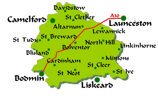
Bodmin Moor, like the Isle of Wight, is lozenge-shaped. It lies at the heart of Cornwall and is crossed from the south west to the north east by the St Michael Line, much as the A30 on the map.
There is a link seemingly between stones and lozenges; it may be of Iberian Celtic origin. Etymonline says
Lozenge
c.1327, from O.Fr. losenge "windowpane, small square cake," etc., used for many flat quadrilateral things. Cognates in Sp. losanje, Catalan llosange, It. lozanga. Probably from a pre-Roman Celtic language, perhaps Iberian *lausa or Gaul. *lausa "flat stone" (cf. Prov. lausa, Sp. losa, Catalan llosa, Port. lousa "slab, tombstone"), from a pre-Celtic language. Originally in Eng. a term in heraldry; meaning "small cake or tablet (originally diamond-shaped) of medicine and sugar, etc., meant to be held in the mouth and dissolved" is from 1530.
A logan rock (large granite boulders that 'rock') is also called a logging stone. The legend is that rocking stones can read the future if the right questions are asked (like 'tell me the way to Avebury' perhaps) but you'd have to possess phenomenal biceps to make the rock rock.
Bodmin is an area known for mists that can obliterate the view where it is essential to keep to the track unless you're familiar with the whereabouts of the bogs. Cornish standing stones have anthropomorphic names, Hurlers, Pipers, Maidens, which are attributed to Christian spoilsports interfering with fun 'n' games; the stories sound like they're based on Medusa, with her mirror and snakes.
|
|
| |
|
|
|
Mick Harper
Site Admin
In: London
|
|
|
|
These terraformed shapes are ambitious but not impossible for megalithic engineering. The Isle of Wight simply requires a bit of water squirted on the Hampshire chalk to create the Solent (perhaps there were already pronounced river valleys given Hatty's remark about north-flowing rivers). Ireland, also lozenge-shaped, can similarly be created if the original geography was but somewhat helpful.
I have pointed out before that Salisbury Plain, upon which Stonhenge stands and from which line-of-sight observations have to be made, is traditionally the only 'plain' in Britain (if you can think of others, sing out and we'll look for local megalithia) and therefore likely to be artificial. The Avebury environs are fairly unusual too, are they not?
|
|
| |
|
|
|
Hatty
Site Admin
In: Berkshire
|
|
|
|
| Mick Harper wrote: | | That's been dealt with, at least in this proportion of the system. You start at a stone circle (any one). However you have not established the function of the stone circle yet. We'll deal with how you find a stone circle a bit later. |
From what you've just said the function of a stone circle is to tell the traveller where to start travelling. The Merry Maidens circle in Bodmin is interesting; apparently the highest stone is to the south west of the circle and the stones' height decreases progressively to the north east which sounds like the laws of perspective are being shown in stone. There's a gap to the east of the circle...the exit?
There has to be an obvious signpost, perhaps cup and ring markings, pointing towards the 'highway' and if you see one of these signs you know you're off the beaten track but heading in the right direction.
You have not been attending. These are for when you have lost the highway and wish to regain it. |
That's what I said.
| The cup-and-ring system tells you which side of the highway you are. However if you are in any doubt you can always resort to the 'map' provided by the original stone circle. |
Ah. The stone circle is a map. That's neat. Like the junctions on a motorway with routes leading outwards.
| Well, you are already lost because you have failed to follow signs that could be seen from a reasonable distance (ie the leylines). But in any case, missing Avebury entirely is sufficiently serious to ensure that the system takes 'special measures'. It is all dealt with in my last blue post. Hidden in plain site!. |
There were stone markers that have since been scattered/reused/otherwise vandalised?
|
|
| |
|
|
|
Hatty
Site Admin
In: Berkshire
|
|
|
|
| Which reminds me, nobody has yet answered my challenge to produce a fool-proof way of preventing travellers missing Avebury altogether. |
If the track came to a 'dead end' you'd have to retrace your footsteps and get back on track.
|
|
| |
|
|
|
|
