| View previous topic :: View next topic |
Mick Harper
Site Admin

In: London
|
|
 |
|
|
Boreades, if you are going to use these relatively public facilities you must use relatively public maps. Just post up the maps. I could not follow your private Google instructions.
|
|
 |
|
 |
|
Boreades

In: finity and beyond
|
|
|
|
| Mick Harper wrote: | | Boreades, if you are going to use these relatively public facilities you must use relatively public maps. Just post up the maps. I could not follow your private Google instructions. |
Don't get huffy with me, complain to Google. It's not private if you've been given Editor privileges.
|
|
| |
|
|
|
Mick Harper
Site Admin
In: London
|
|
|
|
|
I get huffy with people who want everyone to go through various hoops (which don't work for one reason or another) to join organisations they may not want to join rather than just posting up things for all to see.
|
|
| |
|
|
|
Mick Harper
Site Admin
In: London
|
|
|
|
| "My" Michael Line must be deviant, or maybe it should be a Great Circle, because all the famous points seem to be slightly north of a direct line i.e. a direct line according to Google Maps, not Google Earth. Which might or might not explain the difference? |
Since I can't see your map I am none the wiser. What are you using for datum points? The Michael Line can use various anchors.
|
|
| |
|
|
|
Boreades
In: finity and beyond
|
|
|
|
|
It's no good me posting screen grabs of the Google map here, because if I make it big enough to show any worthwhile detail, you will be Screaming Blue Murder at the width of the thing!
|
|
| |
|
|
|
Boreades
In: finity and beyond
|
|
|
|
As a peace offering, try this link to a free copy of Puck of Pook's Hill. By Rudyard Kipling. He tells the sad story of Wayland (Weland) the Smith:
'All sorts of sacrifices,' said Puck. 'If it wasn't men, it was horses, or cattle, or pigs, or metheglin - that's a sticky, sweet sort of beer. I never liked it. They were a stiff-necked, extravagant set of idols, the Old Things. But what was the result? Men don't like being sacrificed at the best of times; they don't even like sacrificing their farm-horses. After a while, men simply left the Old Things alone, and the roofs of their temples fell in, and the Old Things had to scuttle out and pick up a living as they could. Some of them took to hanging about trees, and hiding in graves and groaning o' nights. If they groaned loud enough and long enough they might frighten a poor countryman into sacrificing a hen, or leaving a pound of butter for them.
I remember one Goddess called Belisama. She became a common wet water-spirit somewhere in Lancashire. And there were hundreds of other friends of mine. First they were Gods. Then they were People of the Hills, and then they flitted to other places because they couldn't get on with the English for one reason or another. There was only one Old Thing, I remember, who honestly worked for his living after he came down in the world. He was called Weland, and he was a smith to some Gods. I've forgotten their names, but he used to make them swords and spears. I think he claimed kin with Thor of the Scandinavians.' ....
'It was Weland's Ford then, dearie. A road led down to it from the Beacon on the top of the hill - a shocking bad road it was - and all the hillside was thick, thick oak-forest, with deer in it. There was no trace of Weland, but presently I saw a fat old farmer riding down from the Beacon under the greenwood tree. His horse had cast a shoe in the clay, and when he came to the Ford he dismounted, took a penny out of his purse, laid it on a stone, tied the old horse to an oak, and called out: "Smith, Smith, here is work for you!" Then he sat down and went to sleep. You can imagine how I felt when I saw a white-bearded, bent old blacksmith in a leather apron creep out from behind the oak and begin to shoe the horse. It was Weland himself. I was so astonished that I jumped out and said: "What on Human Earth are you doing here, Weland?"'
'Poor Weland!' sighed Una.
'He pushed the long hair back from his forehead (he didn't recognize me at first). Then he said: "You ought to know. You foretold it, Old Thing. I'm shoeing horses for hire. I'm not even Weland now," he said. "They call me Wayland-Smith."'
'Poor chap!' said Dan. 'What did you say?'
'What could I say? He looked up, with the horse's foot on his lap, and he said, smiling, "I remember the time when I wouldn't have accepted this old bag of bones as a sacrifice, and now I'm glad enough to shoe him for a penny."
"'Isn't there any way for you to get back to Valhalla, or wherever you come from?" I said.
"'I'm afraid not, " he said, rasping away at the hoof. He had a wonderful touch with horses. The old beast was whinnying on his shoulder. "You may remember that I was not a gentle God in my Day and my Time and my Power. I shall never be released till some human being truly wishes me well."
|
|
| |
|
|
|
Chad

In: Ramsbottom
|
|
|
|
| Mick Harper wrote: | | Chad once said that 'his' Michael Line passed straight through Avebury stone circle |
Not me Guv. Think it might have been Keimpe.
Give me the most important datum points (and/or the recognized terminal points) and I'll do a "best fit straight line" on Google Earth. Then we can see where the Cheese Ring lies in relation to it.
|
|
| |
|
|
|
Mick Harper
Site Admin
In: London
|
|
|
|
Here's the best I can manage. Feel free to wriggle within reason
1. The tip of Land's End (not St Michael's Mount, though that can be used too if it works better) as the western anchor
2. Ormesby St Michael on the Norfolk coast (or the gap between Ormesby St M and Ormesby St Margaret if that works better) as the eastern anchor
3. Alternatively use a line running through the Avebury Circle in the east and one of the Cornish Michael tors on the west.
PS If you can help me join Boreades' Magic Google Circle I'd be much obliged.
|
|
| |
|
|
|
Hatty
Site Admin

In: Berkshire
|
|
|
|
The Cheesewring is right beside the Michael Line, the orthodox line between Land's End and Hopton, as per Google Earth.
Trouble is Google's stipulations mean the map can't be reproduced in a DVD without breaching copyright.
|
|
| |
|
|
|
Hatty
Site Admin
In: Berkshire
|
|
|
|
|
Megalithic forum is back on track. Thanks to Keimpe as ever.
|
|
| |
|
|
|
Chad
In: Ramsbottom
|
|
|
|
| Hatty wrote: | The Cheesewring is right beside the Michael Line, the orthodox line between Land's End and Hopton, as per Google Earth.
Trouble is Google's stipulations mean the map can't be reproduced in a DVD without breaching copyright. |
How about reproducing the Google result manually on a non-copyrighted map and simply stating that the position was verified using Google Earth?
|
|
| |
|
|
|
Mick Harper
Site Admin
In: London
|
|
|
|
Never you mind your pretty little head about legal issues, I need somebody I can trust (ie a man who can park cars) to tell me "the Michael Line runs within a hundred yards of the Cheeswring, using such and such parameters".
When it comes to the DVD we shall just redraw the map (to avoid legal issuers) and choose a scale that diminishes a hundred yards (ONO) to nothing. Those of you have watched the Glastonbury DVD will easily recognise that this technique of "By God and by hand" is quite sufficient to generate a line [the Maritime Michael Line] that does what you want it to. I would maintain perfectly fairly.
|
|
| |
|
|
|
Hatty
Site Admin
In: Berkshire
|
|
|
|
The Google Earth line has been tweaked slightly to ensure the Michael Line from Land's End would pass through Avebury at The Red Lion, slap bang on the (swastika-like) crossroads, instead of passing further north between Winterbourne Monkton's St Mary Magdalene Church and the Avebury complex.
This line ends up at Corton on the Suffolk coast a few miles south of Hopton. Tracing the redrawn line, it seems to follow the same course as something called the Angles Way which turns out to be a long-distance trackway close to the Norfolk/Suffolk border connecting Great Yarmouth to Thetford, the site of Edmund the Martyr's martyrdom and Grimes Graves mines.
Wiki says the Angles Way originally went only to Knettishall Heath, a meeting place of more main trackways, The Icknield Way, Peddars Way and the Norfolk Coastal Path. Angles Way is a new one to me but it's presumably old.
|
|
| |
|
|
|
Mick Harper
Site Admin
In: London
|
|
|
|
|
I was talking to Chad. Still, this helps. What is the relationship of this line to the various tors, especially Glastonbury Tor? Can anyone post up a few actual maps.
|
|
| |
|
|
|
Hatty
Site Admin
In: Berkshire
|
|
|
|
This is the Michael Line, Land's End to Corton version which Boreades has put in red to make it easier to see.
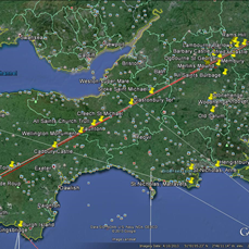
Creech St Michael, Burrowbridge Mump and Glastonbury Tor are on or near the line.
|
|
| |
|
|
|
|
