| View previous topic :: View next topic |
Mick Harper
Site Admin

In: London
|
|
 |
|
|
I do not follow your reasoning but we are not presently concerned with causation, only with correlation. Should the correlation be overwhelming, the reason for the correlation will presumably follow. If you can discover anywhere in the world that is a) a desert and b) within 500 kms of an ocean on its eastern side, then the correlation is destroyed; if you can't, it is established.
|
|
 |
|
 |
|
Chad

In: Ramsbottom
|
|
|
|
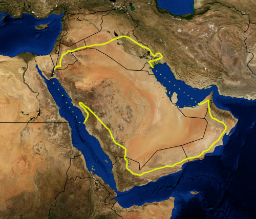
The Arabian desert, on initial inspection, does appear to have areas within 500km of the India ocean (which lies directly to the east).
|
|
| |
|
|
|
Hatty
Site Admin

In: Berkshire
|
|
|
|
|
Ignoring the reason(s), there is a clear correlation.
|
|
| |
|
|
|
Mick Harper
Site Admin
In: London
|
|
|
|
We have had constant problems with both the Arabian peninsula and the Horn of Africa because of the dubiousness of local rainfall statistics (a highly political business!). Perhaps you could post up a political map of both areas showing (very remarkably and one must assume very significantly) that the political boundaries (between Saudi Arabia and its littoral eastern and southern neighbours, and between Ethiopia and Somalia) obey the Eastern Effect rule with great fidelity.
Two flubfactors to bear in mind:
1. The Persian Gulf, like the Red Sea, may not count as ocean.
2. 500 kilometres might not be the correct number (I've never actually measured it) and in any case the number might vary (for instance with latitude).
However keep the doubtful examples flowing in eg Greenland and Antarctica.
|
|
| |
|
|
|
Ishmael

In: Toronto
|
|
|
|
| Mick Harper wrote: | | ...(The actual figure of the Eastern Effect has never been worked out, some of you could make yourselves useful...) |
Not quite true.
While I have not quantified the figures for the globe, because I have correctly identified the factors involved, I do know how to calculate the equation.
|
|
| |
|
|
|
Ishmael
In: Toronto
|
|
|
|
| Mick Harper wrote: | | We have had constant problems with both the Arabian peninsula and the Horn of Africa... |
You should read the material I wrote for you (and if you plan to write a book on the subject, it's practically already written). I have solved all of these problems.
|
|
| |
|
|
|
Chad
In: Ramsbottom
|
|
|
|
| Mick wrote: | | 2. 500 kilometres might not be the correct number (I've never actually measured it) and in any case the number might vary (for instance with latitude). |
Yes, I strongly suspect this is the case. Each individual region probably has its own specific limit... as you say it may be dependent upon latitude or perhaps altitude. But I quite fancy the idea that it is a balance between the forces of the west and those of the east.
In the case of the Arabian peninsula (which is basically just part of the Sahara) the forces of the west (dry desert air and overwhelming quantities of sand) have simply swamped whatever resistance the forces of the east can put up against them.
|
|
| |
|
|
|
Ishmael
In: Toronto
|
|
|
|
| Chad wrote: | | Yes, I strongly suspect this is the case. Each individual region probably has its own specific limit... as you say it may be dependent upon latitude or perhaps altitude. |
Not directly.
It's a factor of wind speed.
|
|
| |
|
|
|
Mick Harper
Site Admin
In: London
|
|
|
|
|
Yes, well, I'd like the raw figures before I go whoring after multiple gods. The trouble with you lot is that you have no faith in simplistic nostrums. You should all be working on Australia at the moment.
|
|
| |
|
|
|
Hatty
Site Admin
In: Berkshire
|
|
|
|
Australia bears out what your theory says but I expect my interpretation is too simplistic.

The desert is on the Pacific coast to the west, east of the high ground is non-desert. The south-west coast is less than 500 or so km from the sea on the east reminiscent of the tip of South America. The north and north-east are practically on the same latitude as Indonesia.
Higher rainfall in the centre than on the eastern littoral doesn't accord with what you'd expect from the theory assuming the stats are correct.
|
|
| |
|
|
|
Mick Harper
Site Admin
In: London
|
|
|
|
First of all let us set Australia in its basic hydrological context. If you shade in a swathe of territory representing the latitudes to the west of Australia you will get a) Indian Ocean b) a relatively narrow chunk of a relatively dry part of southern Africa and c) Atlantic Ocean. This does not represent much in the way of greenery so Australia is doomed to be 'the desert continent'.
But there are green chunks which we need to account for. It is not for two reasones advanced by Hatty. The fact that ferociously wet Indonesia lies to the north is irrelevant, precipitation is an entirely east-west business; the fact that Australia has a continuous north-south mountain barrier (The Great Dividing Range) is irrelevant because it is too near the eastern coast to have any effect.
Look at the rainfall map. We are defining deserts as >10 inches (or >240 mm) so we have to account for the yellow/orange parts on one hand and the green/blue on the other. The first thing to note is the triumphant vindication of the eastern effect as the eastern boundary of the desert mimics the curve of the east coast with such fidelity that the overall principle can scarcely be any longer in doubt.
However there are two places where only a fudge keeps the principle going. In the north the light green goes too far west (we shall be dealing with this in a mo) and in the south Adelaide and the ickle green bit on the other side of the inlet should not be green However this map is slightly skewed (it is not oriented exactly east-west), and if you set that straight you will find that Adelaide is green because Perth is green. In other words the amount of verbiage to the west suddenly triggers an outbreak of non-desert conditions further east. [There is an alternative theory that the sea inlets produce Eastern Greenery which then trigger Western rainfall but these inlets seem very small for such a startling effect.)
Perth and Fremantle are in turn green because of the Easterly Effect of the Great Australian Bight. However there are two caveats here. First of all the GAB does not produce a full easterly effect and the reason for this (not presently known) will presumably assist in isolating the precise cause of the Eastern Effect. But the GAB cannot account for the northern extension of the Perth area fertile zone. This may be because of modern irrigation intervention (researchers please advise) or it may be out-of-Africa (see below).
The northern blue strip of Australia is non-desert for Eastern Effect reasons. Notice that a) the tip of Queensland is blue because of the Pacific Ocean b) Arnhemland is blue because of the Gulf of Carpentaria and c) the next blue bit is caused by the next inlet of the ocean. Each bit of Eastern Effect then in turn becomes a westerly feeder of water vapour but no amount of jiggery will account for the light green strip crossing Australia. Since it is very flat ie an obvious west-to-east strip, we can readily suppose that this is being (lightly) triggered by foliage factors in Africa which at these latitudes is relative wide and relatively wet, even though relatively far away. This (in the form of Madagascar) will probably also account for the northern Perth salient.
But anyway, all in all, Australia is as much subject to the OGRE Rules of Hydrology as sub-equatorial Africa and South America were. What OGRE is will be explained later today. Meanwhile, somebody put up a precipitation map of Antarctica.
|
|
| |
|
|
|
Chad
In: Ramsbottom
|
|
|
|
| Meanwhile, somebody put up a precipitation map of Antarctica. |

The scale is in mm (liquid eqivalent).
Since there is no vegetation anywhere at Antarctic latitudes, Antarctica is understandably mostly desert (everything up to and including the white bits)... we just need to explain the peninsular and coastal precipitation.
I think it may have something to do with the unbalancing of the sea-level evaporative equilibrium, caused by glacial melt water in the peninsular region.
|
|
| |
|
|
|
Hatty
Site Admin
In: Berkshire
|
|
|
|
| The fact that ferociously wet Indonesia lies to the north is irrelevant, precipitation is an entirely east-west business; the fact that Australia has a continuous north-south mountain barrier (The Great Dividing Range) is irrelevant because it is too near the eastern coast to have any effect. |
If you look at the globe Indonesia isn't "to the north". It's almost on the same latitude and north-west Australia is practically touching (lush) New Guinea.
| Since it is very flat ie an obvious west-to-east strip, we can readily suppose that this is being (lightly) triggered by foliage factors in Africa which at these latitudes is relative wide and relatively wet, even though relatively far away. This (in the form of Madagascar) will probably also account for the northern Perth salient. |
Is it me or are you saying the exact opposite of what you said vis-a-vis South America? Such a vast expanse of ocean to the east would surely outweigh "foliage factors". And you haven't explained why the south-west isn't desert too.
|
|
| |
|
|
|
Ishtar

|
|
|
|
| Mick Harper wrote: |
Perth and Fremantle are in turn green because of the Easterly Effect of the Great Australian Bight. However there are two caveats here. First of all the GAB does not produce a full easterly effect and the reason for this (not presently known) will presumably assist in isolating the precise cause of the Eastern Effect. But the GAB cannot account for the northern extension of the Perth area fertile zone. This may be because of modern irrigation intervention (researchers please advise) or it may be out-of-Africa (see below). |
Perth area has a good amount of forest zone right on the west coast and there is a lot of "dryland farming" or farming without irrigation.

I do see this area lining up to the southern tip of Africa and a good amount of South America at about 30 degrees south
|
|
| |
|
|
|
Mallas

|
|
|
|
Mick I found that chart I was talking to you about that shows that foliage growth has increased due to a decline in cloud cover. I think you said something to me about deserts expanding due to decreased cloud/rain, but these seem to show otherwise.

Also regarding plant growth in Australia I found this:
Similarly, an Australia-wide analysis of satellite data for 1981--2006 indicates that vegetation cover has increased average of 8% (Donohue et al. 2009).

Australia, 1981-2006. Change in vegetation cover, as described by the fraction of Photosynthetically Active Radiation absorbed by vegetation (fPAR). Source: Donohue et al. (2009)
|
|
 |
|
|
|
|
